Information about the licenses of the maps shown can be found at the end of this article!
This text was translated with the help of Deepl!
The english version of this content is outdated, please use the google translated version: Translated article
The recently released Garmin Fenix 6 Pro is in my opinion the best outdoor watch and comes with the free "TopoActive" card.
This map is - in my opinion - based on OSM (OpenStreetMap), but it lacks details and does not fit the high standard of such a high quality watch. In addition, the map is limited, not even Crete is included.
If you want to have a more detailed map for the Alps on the Fenix, you can also buy the TOPO TransAlpine+ PRO from Garmin for ~ 150 €, but I advise against it, because this map contains the same absurd errors as the maps from Outdooractive.
Paths lead in canyons, do not exist, the actual paths are missing, an impudence to charge money for them. The mistakes are so ridiculously obvious, for example, paths lead 30m past the summit (front solstice pass).
Paths have been straightened with a ruler or wind their way through the landscape like a sine curve and can never have existed as one can easily see on the spot or on aerial photographs.
In places, paths lead through buildings or run exactly on slopes, for example west of the Oberföhring Volunteer Fire Brigade. The fact that this error can also be found in Google Maps doesn't make it any better, but you can't plan a bike tour with this map in the city.
In my opinion this is not only true for Garmin, but also for Outdooractive. Unfortunately, these are the only maps I know of (and which can be used in planning software) with a slope gradient layer, which is very useful for planning tours in the snow in winter. Since I bought the maps for the winter, because you can't see the trails when there is a lot of snow, this is especially annoying, if not dangerous for me.
I called the support of Garmin about these map errors in the TOPO TransAlpine+ PRO, they insisted that the TOPO TransAlpine+ PRO is based on OSM, but that can't be true, because you won't find trails in OSM, in my opinion official map material is used, that was the statement of Outdooractive to me, when I asked for correction many years ago. They also told me that they would not correct the mistakes because of that.
To make this clear once again: The mentioned errors are not to be found in the TopoActive map of Garmin, because it uses the clearly better map material of OpenStreetMap, but in a reduced version.
A very good alternative to the maps available at Garmin is the OSM-based map from www.freizeitkarte-osm.de, which I recommend, with a small adjustment, for the Garmin Fenix 6.
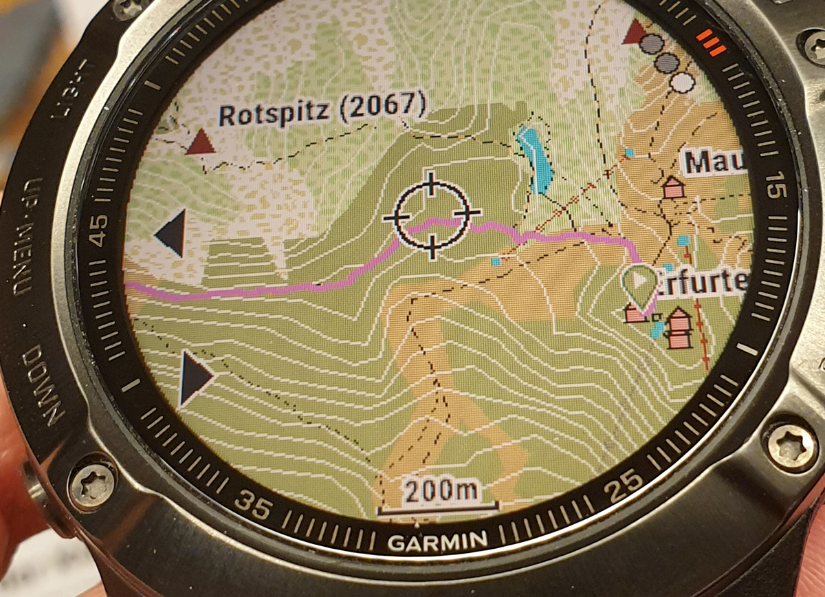
The following instructions also work for example with a Fenix 5, in the example I use a Fenix 6X Sapphire.
Installation of the leisure map on the Fenix
What do you need for the installation?
Prepare your PC as follows:
- Connect the Garmin Fenix via USB
- You have installed Garmin Basecamp and the Fenix is also recognized
- Optional: You have installed JaVaWa GMTK (http://www.javawa.nl/gmtk_en.html)
Download the maps
Download the maps now. You can install countries or regions, for example, in the case of regions there is a map that includes the Alps.
For Germany select on the download page for Germany: https://www.freizeitkarte-osm.de....the following :
German -> Deutschland - GMAP Installationsarchiv (complete) for Garmin BaseCamp
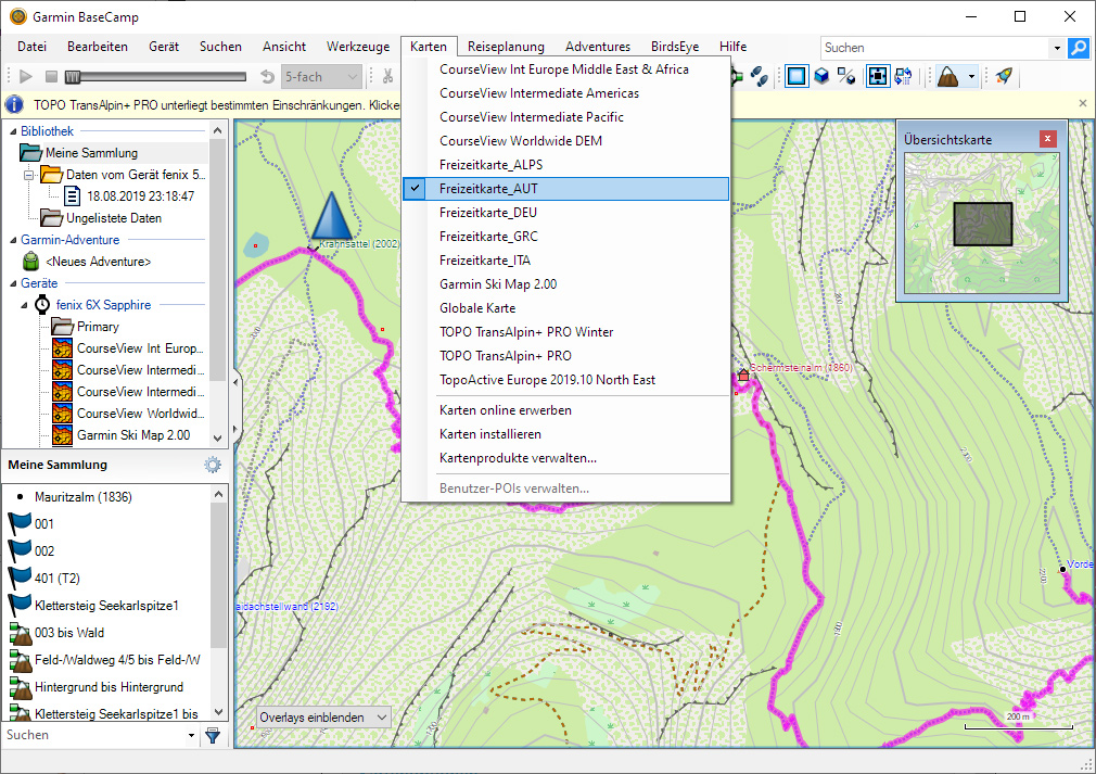
After the download you unpack the map and then install it. After the installation you start Garmin Basecamp and check if the map is available, as shown here with the example of the Austrian map:
Installing the card on the Fenix
Before you take this step, first read the paragraph Oh dear, the card does not look nice, what now?
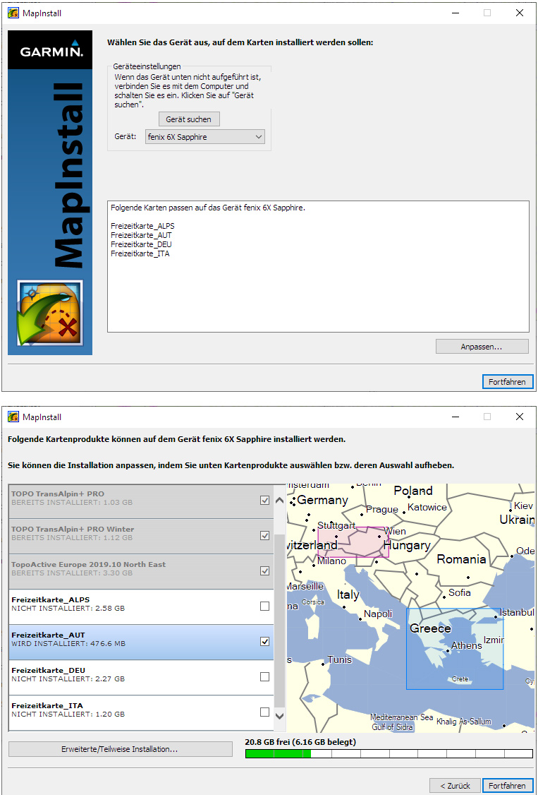
To transfer the map to Fenix, use the software Garmin MapInstall. You can find it under Windows in the start menu, or in Basecamp under "Maps -> Install maps".
In MapInstall you simply click through the wizard, then the map (or several maps) will be transferred to the Fenix:
Using the map on the Fenix
On the Fenix there are several methods of using the map. I configure the map in the activity and use previously planned routes. For this I proceed like this:
- Start activity, in my case: "Climbing"
- Press the "UP" button in the next screen to access the options.
- Then switch to "Mountaineering settings
- Then switch to "Map
- Then switch to "Configure cards
- Then only activate the desired map -> is shown with a green bar on the right.
- Exit options
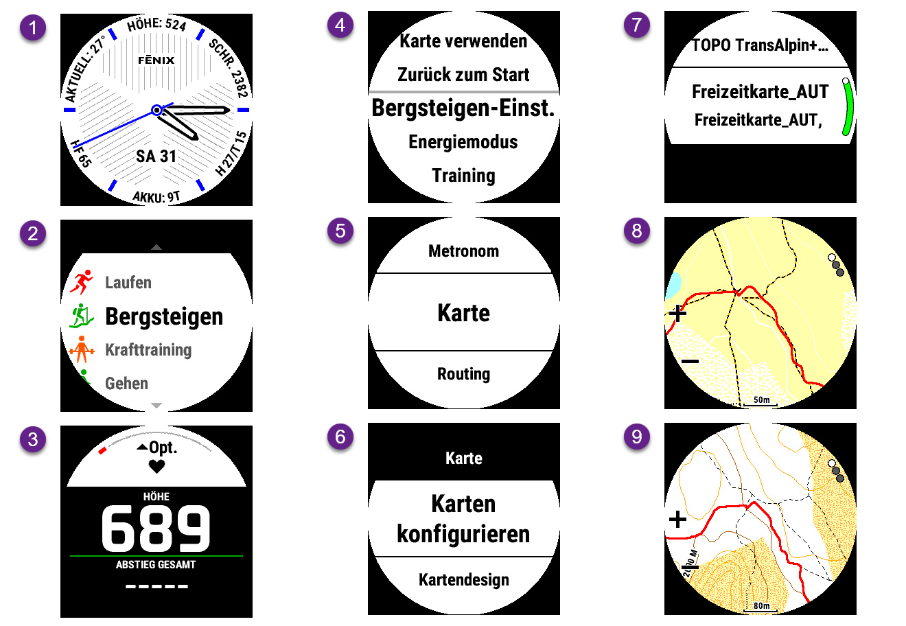
Now I end the activity and start it again for better handling
- Start activity, for me: "Mountaineering"
- Press the "UP" button in the next screen to access the options.
- Then switch to "Stretch
- Select route
- Then "Start route"
Oh dear, the map does not look nice, what now?
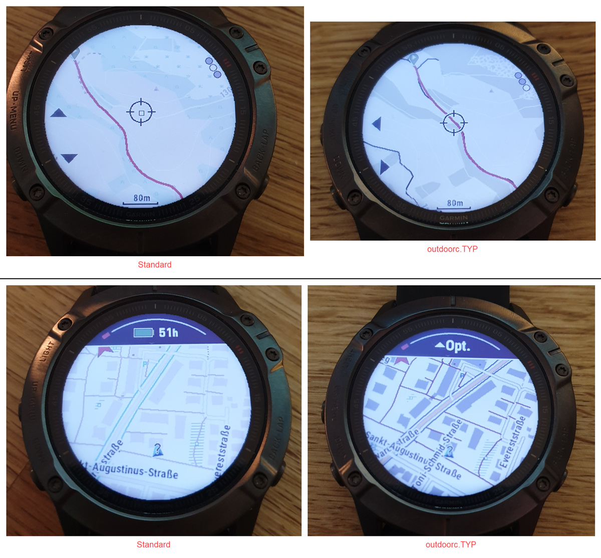
What still looks good in the screenshots above, is no joy on the transflective, and thus quite poor in contrast and color, display of the Fenix.
Especially the fine dotted lines, which represent paths, are drowning. Although you have the possibility in the Fenix 6 to increase the contrast of the map within the Fenix (the 5s can't, as of 08.09.2019), I didn't like the results that much. But the fact that Garmin offers this possibility shows that the topic is known there and that they have implemented an optimization possibility here.
The, IMHO, better solution can be found here: https://www.freizeitkarte-osm.de..., as you can see there, there are different type files that influence the look of the map.
The following picture shows 2 versions of the same map, I personally like the design "outdoor-contrast" (outdoorc.TYPE) very much, you can see the comparison on the right side.
Notice how the dotted light/medium grey markings of the paths turn into easily recognizable dark grey lines.
How do you change the design of the card?
The easiest way is to download the zip file "ReplaceTyp.zip" for Windows here https://www.freizeitkarte-osm.de... and extract it.
Then use the previously installed program JaVaWa GMTK to apply a different TYPE file to it, as shown on the following screenshots.
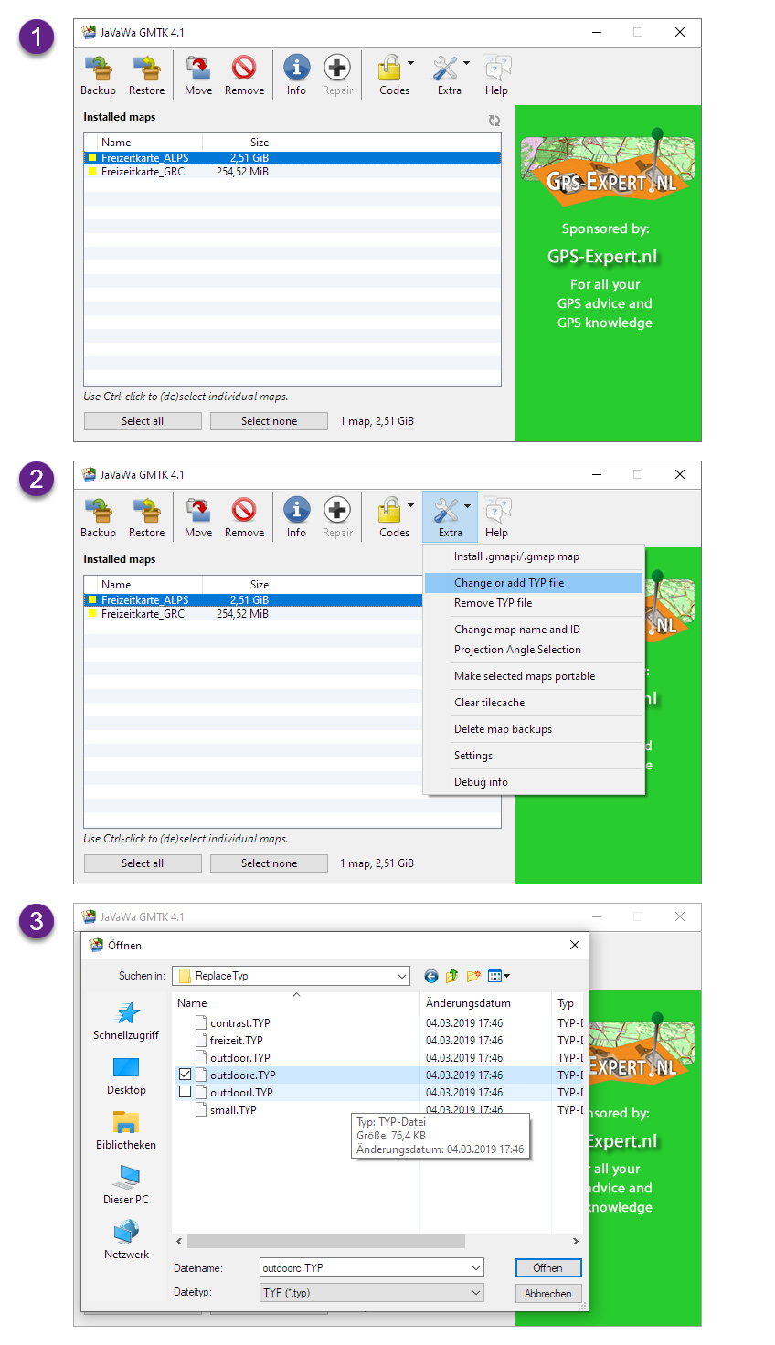
Then you transfer the maps again with MapInstall. If you have already installed the map, remove it with MapInstall, the process is similar to the installation.
Use your own type file?
For me the representation was still too dull, so I work with my own TYPE file, you can see the results here:

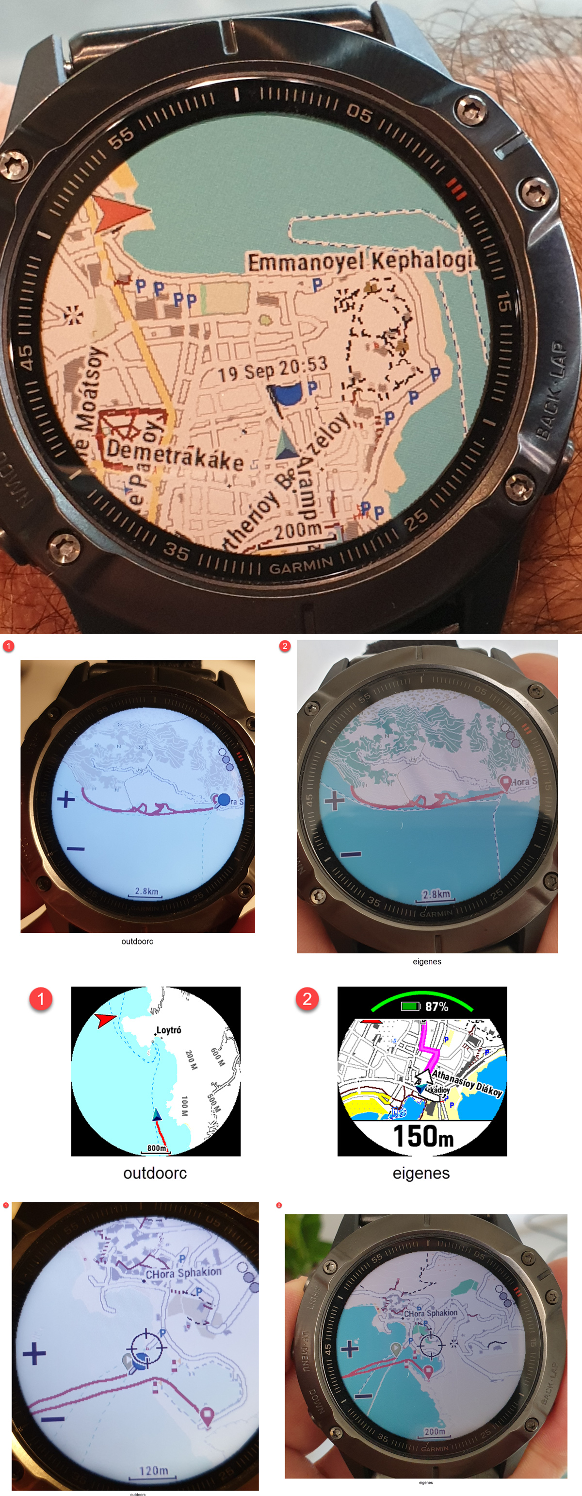
If you are interested, you can download the type file here: https://github.com/..... recently mountain tops are also shown.
Licenses of the maps shown
Die folgenden Informationen zu den Lizenzen stammen von hier https://www.freizeitkarte-osm.de/garmin/de/impressum.html
Du findest dort auch eine Möglichkeit, an das Projekt zu spenden.
Nutzung des Kartenmaterials:
Die Nutzung des Kartenmaterials erfolgt auf eigene Gefahr. Das Kartenmaterial und oder das Routing kann Fehler enthalten oder unzureichend sein. Die Ersteller dieser Karten übernehmen keinerlei Gewährleistung oder Haftung für Schäden die direkt oder indirekt durch die Nutzung des Kartenmaterials entstehen.
Lizenzbedingungen der Kartendaten:
Map data © OpenStreetMap contributors (ODbL).
Die dargestellten Kartenobjekte basieren auf den Daten des OpenStreetMap-Projektes.
OpenStreetMap ist eine freie, editierbare Karte der gesamten Welt, die von Menschen wie dir erstellt wird.
OpenStreetMap ermöglicht es geographische Daten gemeinschaftlich von überall auf der Welt anzuschauen und zu bearbeiten.
Link: http://www.openstreetmap.org/
Lizenz: http://www.openstreetmap.org/
Lizenzbedingungen der Höhenlinien:
Contour data © U.S. Geological Survey (public domain).
Die Höhenlinien basieren teilweise auf Daten von U.S. Geological Survey.
Link: http://dds.cr.usgs.gov/
Lizenz: http://eros.usgs.gov/
Contour data © J. de Ferranti (free for research and private use).
Die Höhenlinien basieren teilweise auf Daten von Jonathan de Ferranti.
Link:
http://www.viewfinderpanoramas.org/
Lizenz:
http://www.viewfinderpanoramas.org/
Lizenzbedingungen der Karten:
Produced map © FZK project (free for research and private use).
Die hier verfügbaren Karten stellen ein aus den Karten- und Höhendaten abgeleitetes Werk (produced work) dar.
Die Karten können für private oder wissenschaftliche Zwecke frei (uneingeschränkt) genutzt werden.
Bereitstellung der OpenStreetMap-Kartendaten:
Tagesaktuelle länder- und regionsspezifische Extrakte der OSM-Datenbankdaten werden uns durch die Firma Geofabrik GmbH (Karlsruhe) zur Verfügung gestellt.
Link: http://www.geofabrik.de
Erstellung der Karten:
Alle Karten wurden mit den Tools "splitter" und "mkgmap" erstellt.
Link: http://www.mkgmap.org.uk/
Lizenz: http://gnu.org/licenses/gpl.html
Erstellung der Höhenlinien:
Die Höhenlinien wurden mit dem Tool "phyghtmap" erstellt.
Link: http://katze.tfiu.de....
Lizenz: http://gnu.org....
Markenzeichen:
Garmin® is a registered trademark and BaseCamp™ is a trademark of Garmin Ltd. (http://www.garmin.com) or its subsidiaries.
Mac OS® is a registered trademark of Apple Inc. (http://www.apple.com).
Windows® is a registered trademark of Microsoft Corp. (http://www.microsoft.com).
Hinweis auf weitere Unterlagen:
Die Beschreibung der Kartenelemente in den Legenden erfolgte in Anlehnung an die Definitionen unter:
http://wiki.openstreetmap.org...
Die Beschreibung einiger Routingeigenschaften erfolgte in Anlehnung an die Definitionen unter:
http://wiki.openstreetmap.org...

